To get a deeper understanding of place, infrastructure and community here, we’d like to talk with as many people living in Wisbech, Boston and Peterborough as we can. We want to hear from you the experts about what the strengths and challenges are of where you live. We believe that the rest of the UK can come and learn about the good things happening here as well as the policy solutions we might need to adapt to a changing world.
Imagine you were taking the Prime Minister on a walk around where you live. What makes this place a good place to live? What challenges do you encounter day to day? What can we do about them, together? What can government, local and national, do to help? What power would you like to have in your life, and in your communities, to make things better?
We’re planning to produce a report and short film at the end of 2024 and we’d love your input.
Fenlandia is a visionary interdisciplinary initiative, committed to celebrating, preserving, and interpreting the rich cultural and environmental heritage of the Fenland basin in the United Kingdom’s East Anglia region.
This initiative integrates diverse artistic platforms – including visual arts, music and heritage projects – in both conventional and unexpected locations. Unlike district-specific initiatives, Fenlandia seeks to draw upon the entire Fenland basin, representing its rich heritage and ecological significance in a holistic and all-encompassing manner.
In Ely Cathedral currently there is a large table, which is being installed in the north aisle of the nave. It is currently covered over but will be revealed this week.
The story of the table, from discovery of the oak in a field, to the finished table is told on the website which can be linked to below.
Bog oaks are occasionally found in the peat, excavated by farmers. The one used to make the table is over 13 metres long and over 5000 years old. It has space for 50 people.
One of the interesting aspects of the project was the extent to which the wood shrank as it dried out, and the amount of water that came out of the wood.
Holme Fen is a location where the shrinkage of the Fen as it dries out can be fully appreciated as a post was driven into the ground. Here's some of my photos of the posts taken on a visit some years ago:
Every day on the way to work in Ely, I pass the turning to Welney Wetland Centre.
This is operated by the Wildfowl and Wetland Trusts, and is famous for its floodlit swan feeding sessions, amongst other things. They are currently involved in Project Godwit: a five-year EU Life funded project that is aiming to secure the future of breeding black-tailed godwits in the UK through habitat management, research, supplementing the population through headstarting, and engaging local communities.
Project Godwit is a partnership between RSPB and WWT with major funding from the EU LIFE Nature Programme, the HSBC 150th Anniversary fund, Natural England, the Heritage Lottery Fund, through the Back from the Brink Programme, and Leica UK.
The project aims to secure the future of black-tailed godwits in the Fens.
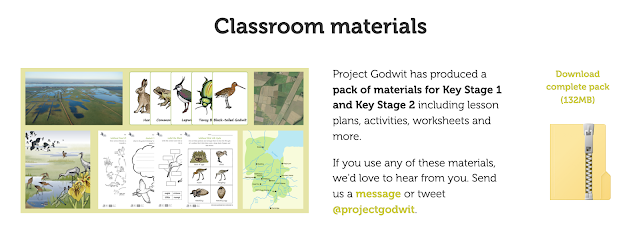
The project has already created a series of educational resources for KS1 and 2 students, which cover quite a few subjects including Geography. They can be viewed here.
They will be perfect for our Year 4 unit on The Fens.
It's a short film which has been made by Rowan Jaines as part of her work on the Cultural Geography of the Fens. It focuses on the Cambridgeshire Fens, through which I travel on a normal work day and have done for the last eight years.
This video essay is part of a four-year research project exploring the cultural geography of the Fen region in the East of England.
The film is made up of a bricolage of clips of the Fen region, scavenged from the internet and put together in a piecemeal fashion so that the images on screen both intensify and disrupt the linear arc of the narration.
This is a film that aims to show the Fens as haunted by both the past and those things that have not yet come to be.
I am currently putting together an updated unit on the Fenland landscape.
Elements of this will be used in 2021.
This image here is of the 'famous' leaning tree in Ely which I've photographed many times over the years.
The Fens Biosphere project has received funding to support its work and has a new website. It aims to have the Fens declared as a biosphere.
A Biosphere is a special status awarded by UNESCO to a unique and valuable landscape. Biospheres connect people, economies and nature to create a secure future we can all look forward to. They are about developing new ways of living, exploring new ideas and working together.
The key characteristics of the area are suggested below:
The geographical boundaries of the Fens Biosphere have been built around the following key aspects of this landscape:
The peat soils, the ‘black gold’ of the Fens. Within the proposed boundary the dominant soil type is peat, intermixed with silt soils. Peat has become a scarce resource due to ongoing peat loss through shrinkage and fen blows caused largely by intense drainage and farming regimes; there is an urgent need to preserve remaining peat soils.
An important food-producing area dominated by Grade 1 and grade 2 soils; farming and food production are at the beating heart of the Fens. There is a need to ensure farming and the food sector remains vital to the local economy.
Extensive ditch and waterways network: Ditches, the ‘upside-down hedgerows’ of the Fens are renowned for their high biodiversity value, the area being a stronghold for many rare species such as spined loach and water voles.
Internationally important lowland wetland habitats (core areas on map), including Nene Washes, Ouse Washes, Wicken Fen and Holme Fen.
Multiple wetland vision projects, such as the Wildlife Trust’s Great Fen Vision, the National Trust’s Wicken Fen Vision and the expanding RSPB Ouse Fen reedbeds.
Several partnership-led initiatives for landscape-scale conservation in the arable landscape, including the Ely Nature-Friendly Farming Zone and Thorney Nature-Friendly Farming Zone.
Big urban populations acting as ‘gateways’ to the more rural Fens landscape: Cambridge; Peterborough; Wisbech
Historic market towns / small cities in the heart of the area: Ely; March; Chatteris; Whittlesey and Fen Edge towns that will feature in the transition zone such as St Ives, Soham, Ramsey and Downham Market.
Cutting-edge R&D, digital industries and innovative high-tech and agri-tech businesses – some of which also operate in the Fens – in Cambridge, the internationally recognised centre of academic research, and the Cambridge – Peterborough enterprise zone.
The number of academic and businesses dealing with sustainability, climate change and agri-tech developments is vast and still growing.
Today's Fenland landscape is essentially the creation of the past 500 years, although some evidence of Roman and early medieval attempts at reclamation can still be seen. This talk explores how successive generations have tried to secure the Fens against flooding, from Vermuyden's work in the 17th century through windmill drainage in the18th, steam in the 19th to diesel and electric power in the 20th, and then the major works that followed the 1947 floods.
Throughout much of the period drainage was further handicapped by administrative confusion and conflicts of interest, for example between drainage and navigation and the hostility of King's Lynn towards inland works that could adversely affect the harbour and the Ouse outfall into the Wash.
This outwardly simple landscape of straight lines and great skies has a hidden complexity: every dyke, field, road, railway and building has a rich story to tell, if you know where to look.
Will be taking a look at this and seeing which of the activities we could perhaps adopt for our geographical exploration of the Fens, which I am going to beef up a little in the new academic year so that we ground our work in the local area before extending further. Kaitlin Ferguson is the artist here.
The Places of Poetry website has launched today.
I mentioned it earlier in the year when I first heard about it.
It is collecting poems which are written about places, which can then be pinned to an interactive map. Click the menu icon top right on the home page for all the details and to add your own poem.
The project has been developed by Paul Farley and Professor Andrew McRae, who says:
“Poetry has been used across the centuries to reflect on places and their histories. We’re using modern technology to reinvigorate this model, and we hope that as many people as possible get involved. We are excited to see where people pin their poems, and what they say about the places that matter to them.”
I went on this morning and added my own poem to the map. You can view and read it here, just outside of the city of Ely.
My poem also has a link to the Ordnance Survey, as it describes the survey of the Fens that was done in 1916, and imagines the challenges facing the surveyors of capturing this fluid and flat landscape with its shifting rivers and streams, only to find that an old Fenland boy spots a mistake. Fast-forward 100 years, and students on a geography fieldtrip, using their smartphones, notice a missing stream on their digital maps...
Why not write / add your own poem to the map to contribute. The map is open for contributions until October, and I look forward to seeing more poems appearing over the next few months.
Here's the poem for those who might like to read it and haven't already...
Year 7 have been exploring some aspects of the Fenland landscape. We are going to be exploring them a little more in the Lent Term.
The Ouse Washes partnership has featured on the blog a few times.They are holding an event in Ely Cathedral which we will try to get along to. The idea of resilience is something we have explored. How does this sit alongside the idea of a distinctive landscape, and maintaining that distinctiveness?